
*** This data lab is under construction***
Lab 4 – Plate Tectonics
If you could travel or live anywhere in the United States, where would you go? Would you visit the dynamic coast of California, with rocky sea cliffs and stunning views? Perhaps you would relax on the broad sandy beaches of the Carolinas, tour beautiful farms in the Midwest, ski the Mountains of Colorado, or even summit the peaks of volcanoes in the Pacific Northwest. Regardless of where you’d choose to explore, you’d experience the consequences of one of Earth’s most long-standing geological processes–Plate tectonics! Although we owe a debt of gratitude to plate tectonics for shaping some of our favorite places (the West Coast, mountains, and volcanoes), we must also acknowledge the hazardous consequences of these processes–earthquakes, tsunamis and volcanic eruptions. In this lab, we explore the relationship between plate tectonics, the dynamic landscapes it shapes, earthquakes, tsunamis, and volcanic eruptions, with a keen eye on one of the most hazard prone areas in the United States–the Pacific Northwest.
 The map above (4.0.1) shows several iconic landscapes of the continental US relative to the location of nearby plate boundaries. NOTE: The image above will be updated and replaced when the latest edition of the widget is available. This image is a place holder.
Learning outcomes
- LO1. Identify and describe the three major types of plate boundaries.
- LO2. Correlate plate boundaries with associated tectonic features, bathymetry, and seafloor age (Activity 4.1).
- LO3. Investigate the distribution of earthquakes and explain how their occurrence relates to the different types of plate tectonic boundaries (Activity 4.2).
- LO4. Explain the geological processes that cause tsunamis (Activity 4.3).
- LO5. Describe how oceanographic instrumentation contributes to tsunami detection and early warning networks (Activity 4.4).
Background information
- Key terms: Divergent plate boundary , convergent plate boundary , transform plate boundary , subduction zone , mid-ocean ridge , seamount , earthquake, epicenter, mid-ocean ridge, transform fault, tsunami
Data collection sources:
Figure 3.0.2 Locations of the OOI data stations and cabled arrays (left). The red box indicates the location of the cabled array that collected the data in this lab. Map of the OOI cabled array near Oregon and Washington (right).

Geologic Background
The theory of plate tectonics is the grand, unifying theory of geoscience. The basic idea is that the outermost layer of the Earth, the solid lithosphere, is brittle and is broken into large pieces called tectonic plates. These plates float on a more ductile but still solid layer called the asthenosphere, which behaves similarly to hot plastic, and allows the overriding tectonic plates to move very slowly about the surface of the Earth.
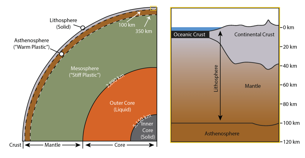
Figure 4.0.2. Earth’s interior is layered, similarly to that of an onion, with layers being defined by either composition or by physical properties. The terms “crust,” “mantle,” and “core” are used to describe compositional differences within the earth, while the terms “inner core,” “outer core,” “mesosphere,” “asthenosphere,” and “lithosphere” describe variation in the physical characteristics of these interior layers. The conceptual diagram on the left side of Figure 4.0.2 illustrates Earth’s distinct layering from the surface to the center of the Earth, while the conceptual diagram on the right side of the figure illustrates variation in the lithosphere (crust and uppermost mantle). A single lithospheric tectonic plate can contain oceanic crust, continental crust, or both (modified from Abbott, 2019)
The tectonic plates can be composed of thin, dense oceanic crustal material or of less dense, more buoyant crustal continental material. Some plates are composed of one or the other, but most include both. Because of the difference in thickness and buoyancy, most oceanic material is geographically the ocean and most continental material is geographically the continent. However, because sea level fluctuates, sometimes the edges of the continents are flooded, making a geographic ocean of geologically continental material! These parts of the ocean are very shallow compared to the true oceanic material.

Figure 4.0.3. Much like the shell of the egg in this image, the outer layer of the earth, or lithosphere, is a brittle layer that is broken into section. These sections are called tectonic plates (image copyright: Benjamin R. Jordan, used with permission; Earth images Google Earth 2021).
Because the tectonic plates are composed of brittle lithosphere, the Earth’s surface is broken into a network of tectonic plates, which resemble the surface of a broken egg (figure 4.0.3), which move relatively to each other, sometimes pulling away from each other, pushing towards each other, or even sliding past each other. We’ll explore the various types of plate boundaries in Lab 4.1, but for now use the widget below to explore these boundaries.
Orientation Questions
Using the widget above, turn on by selecting the Seafloor Age layer. Zoom out so you can see both the Atlantic and Pacific oceans to answer the following questions.
- Which of the following locations are located furthest from a tectonic plate boundary?
a. Mount Hood, Oregon
b. Big Sur, California
c. Breckenridge, Colorado
d. Champaign, IL
e. Charleston, SC - Describe where the youngest and oldest seafloor crust is in the Atlantic Ocean.
- Describe where you find the youngest and oldest seafloor crust in the Pacific Ocean.
Interpretation Questions
Now, using the volcano, earthquake and seafloor age layers on the widget above, (turn them on and off) make observations of their locations in relation to one another as well as the continents and plate boundaries.
- Based on your observations, describe how do you think that scientists know where on Earth plate tectonic boundaries are located?
- Based on your answer to the previous questions, form a hypothesis to describe the relationship between plate boundaries and topographic features.


