Zoom to: North Atlantic, Mid Atlantic, Sandwich Islands, Eastern Aleutian Islands, Western Aleutian Islands, Central America West, South America West, Western US, Equatorial Atlantic, Indonesia, Mariana Islands, Japan, Kuril Islands, Himalayas, Central Indian Ocean
Toggle Layers
Legend
Earthquake Depths
<30 km
30-70 km
70-300 km
300+ km
Volcanoes
Volcano

Bathymetry/Topography

Data Sources
- Bathymetry and topography from Global Multi-Resolution Topography Data Synthesis (GMRT).
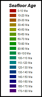
- Seafloor Age (Muller et al, 1997). Provided by SERC.
- Plate boundaries from Peter Bird (2003), Geochemistry Geophysics Geosystems. Available on GitHub.
- Volcanoes from NCEI Volcano Location Database.
- Earthquakes from USGS Earthquakes.
- Large earthquakes dataset includes quakes greater than magnitude 5.5 from 1/1/2001 to 1/1/2021.
- All earthquakes dataset includes quakes greater than magnitude 0 from January, 2021 only.
© 2021 Rutgers University, Rider University IUSE Project